Property line disputes are more common than many landowners realize. A seemingly simple disagreement over where a property begins and ends can escalate into costly legal battles, strained neighbor relationships, and project delays.
In many cases, the root cause of the problem isn’t personal animosity. There is uncertainty about where legal boundaries actually lie. That’s where a boundary survey becomes essential.
This post explains why surveys are critical tools in resolving boundary disputes, how they are used by professionals and courts, and what the typical resolution process looks like. We’ll walk through each step so you know what to expect and how to protect your property rights.
Why Boundary Disputes Happen
Boundary disputes often arise for simple reasons:
- Fences and improvements were installed without a survey
- Property corners aren’t marked or have been lost
- Conflicting plats, deeds, or description errors
- Recent subdivision or changes to adjoining parcels
- Encroachments that went unnoticed for years
Many property owners assume the line on a tax map, aerial image, or fence represents their actual boundary. In reality, only a survey by a licensed professional can determine legal lines.
Because surveys turn legal descriptions into physical reality, they are the first step in resolving disputes.
How a Survey Helps Resolve Disputes
When disagreements arise, the role of the survey is simple but powerful:
- Provide a clear and documented boundary location
- Translate legal descriptions into measured, mapped results
- Serve as trusted evidence in negotiations, mediation, or court
- Identify encroachments, easements, and inconsistencies
A professional boundary survey becomes the baseline data that attorneys, mediators, and courts rely upon when evaluating what’s fair and legally defensible.
To understand the foundation of a boundary survey and what it involves, see our guide on what a boundary survey includes and when it’s needed.
Types of Surveys Used in Boundary Disputes
Different disputes require different survey types. The most common include:
Boundary Survey
This is the standard type used to determine legal property corners and lines. It reviews:
- Legal descriptions
- Recorded plats and deeds
- Physical markers in the field
Retracement Survey
Used when boundary markers have been lost, disturbed, or destroyed, a retracement survey attempts to reconstruct the original survey using historical evidence and professional judgment.
ALTA/NSPS Survey
While ALTA/NSPS surveys are typically used in commercial transactions, they may also be relevant if a dispute involves easements, access rights, or overlapping interests requiring a more detailed legal and physical picture.
For clarity on how these surveys differ, see our discussion on ALTA vs. boundary surveys.
How Surveys Support Dispute Resolution
Let’s walk through the process typically used when a boundary dispute arises:
1. Initiating the Survey
Either party (or both) may request a boundary survey. It begins with gathering legal documents:
- Plats
- Previous surveys
- County records
In some cases, attorneys or title companies request the survey early in the dispute.
Providing the surveyor with all available documentation helps reduce ambiguity.
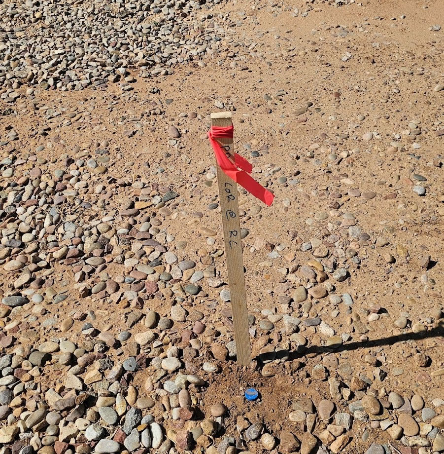
2. Fieldwork and Marker Identification
A licensed survey crew visits the site and seeks existing markers such as:
- Property pins
- Monuments
- Iron rods
- Natural features referenced in legal descriptions
In many Utah properties, markers may be buried or obscured, especially in rural or older subdivisions. The surveyor measures, verifies, and documents these features.
This phase produces the physical data that will be compared with legal records.
3. Comparing Field Data with Legal Records
The surveyor then analyzes:
- Measured distances and angles
- Deed descriptions
- Recorded plats
- Historical surveys
If multiple surveys exist with conflicting information, the surveyor applies priority and retracement rules to determine the most legally defensible lines.
This analytical step is where professional judgment and training matter most.
4. Reporting and Mapping
Once analysis is complete, the surveyor produces:
- A certified boundary map (plat)
- Survey notes and calculations
- Encroachment or easement documentation, if any
This documentation becomes the official evidence for boundaries and any issues uncovered.
5. Sharing Results with All Parties
Once the survey is complete, copies are typically shared with:
- Both landowners
- Attorneys (if involved)
- Title companies
- Government or permitting authorities (if relevant)
This transparency often leads to informal resolution or negotiation.
Approaches to Resolving Disputes After a Survey
Once the survey provides a clear picture, there are several paths to resolution:
Negotiation Between Property Owners
Often the simplest path is for neighbors to review the survey together and agree on a solution. This can include:
- Adjusting fences
- Recording agreed boundaries
- Signing boundary agreements
Many disputes end here when both parties understand the professional data.
Mediation or Professional Arbitration
If informal negotiation stalls, mediation offers a structured way to resolve, often with neutral third-party guidance. The certified survey becomes evidence used by the mediator.
Recording Boundary Agreements
Once an agreement is reached, both parties can record a boundary agreement with county records, making the agreed lines formal and enforceable.
Quiet Title or Court Action
In more contested disputes, attorneys may file a quiet title action in court. A quiet title lawsuit asks the court to declare legal boundaries based on evidence, including:
- Certified survey plats
- Deeds, plats, and records
- Testimony from surveyors
Boundary surveys play a central role in court decisions, since judges rely on documented, professional findings rather than informal claims.
What Happens If the Other Party Disagrees with the Survey?
It’s common for one side to question a survey’s conclusions. Here’s how that situation is typically handled:
Another Survey Is Ordered
The opposing party may hire a separate surveyor. If findings are similar, consensus is easier. If differences arise, both survey reports are reviewed closely:
- Which legal descriptions were used?
- Were field markers located consistently?
- Was the retracement judgment applied correctly?
Surveyors may be called to explain their work.
Expert Testimony
In court or mediation, professional surveyors may testify about their methods, findings, and conclusions. Their expertise helps the judge or mediator interpret technical matters.
Court Evaluates Weight of Evidence
If surveys conflict, courts consider:
- Recency and credibility of data
- Legal precedence and retracement rules
- Whether surveyors followed industry standards
Courts typically favor evidence that aligns with legal descriptions and professional standards.
Avoiding Boundary Disputes Before They Start
While some disputes are unavoidable, many can be prevented by taking proactive steps:
Order a Survey Before You Buy
Especially when purchasing undeveloped land or older parcels, getting a survey early, ideally during due diligence, can prevent surprises after closing. Find guidance on how to order a survey before buying land in our support post.
Share Survey Results with Neighbors
When a boundary is clearly documented, sharing the results with neighbors often preempts future disagreement.
Record Agreements and Easements
Whether it’s a shared driveway or fence line, formal easements or boundary agreements recorded with the county reduce ambiguity and future conflict.
Conclusion: Surveys Bring Certainty, Not Conflict
Boundary disputes can be stressful, but they don’t have to be destructive. The key to resolution is clear, professional evidence, and that’s exactly what a boundary survey provides.
Rather than guessing where the property line lies, a certified survey objectively defines it. Whether conflict resolution happens through negotiation, mediation, or quiet title action, the survey sits at the heart of every legally defensible solution.
If you’re dealing with a boundary disagreement or want to prevent one before it starts, our team can help you navigate the survey process with confidence.
Contact Highland Surveying at (385) 324-7090 or request a quote online to discuss your situation and get expert guidance.